Mot de passe perdu ?
Nouvel utilisateur ? Créer un compte
Big eye, Philippines. Photo by Stephane Rochon.
Appréciez et contribuez !
| Trouvez les meilleurs sites |
|
|
 Kamik
Kamik
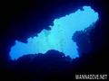
Croatia, South adriatic, Vis Island
Cette carte est interactive ! Utilisez les boutons pour zoomer ou vous déplacer.
|
Datum: WGS84 [ Aide ] |
Latitude: 43° 3.594' N |
Notation (0)
- Favoris
-
Vos sites favoris et futures listes de sites
Accès
|
Comment ? Par bateau Distance Bon trajet par bateau (< 30min) Facile à trouver ? Facile à trouver |
Caractéristiques du site
Autre nom Rock Kamik
Prof. moyenne 25m m / 82 ft
Prof. max 50m m / 164 ft
Courant Faible ( < 1 knot)
Visibilité Bonne ( 10 - 30 m)
Qualité
Qualité du site Bon
Expérience CMAS ** / AOW
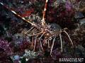
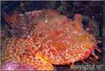
Intérêt bio Intéressant
Plus d'infos
Fréquentation semaine
Fréquentation week-end
Type de plongée
- Tombant
- Profonde
- Grotte
Activités plongée
- Plongée de nuit
- Photographie
Dangers
- Profondeur
Informations supplémentaires
Auteur: juricabozanic Contributeurs (1) Ils ont plongé sur ce site! (3)
 Commentaires
Soyez le(la) premier(e) à commenter ce pays
Erreurs, Réactions
Vous pouvez corriger des erreurs ou ajouter de nouvelles informations sur cette page. Si vous avez d'autres commentaires à faire sur cette page, Dite-le nous.
Annonceurs
Wannadive.net 24/24
Wannadive.net sur votre portable
![]()
RSS Tous les flux RSS de Wannadive.net
Newsletter Toutes les nouveautés par courriel