Lost password? New user? Register
Clownfish, Philippines. Photo by Stephane Rochon.
Enjoy and contribute!
| Find the best dive sites |
|
|
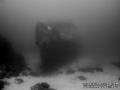
 Imperial Eagle MV
Malta, Malta island
This is an interactive map! Use controls to pan and zoom this map.
|
Datum: WGS84 [ Help ] |
Latitude: 35° 57.096' N |
User rating (1)
- Add dive log
- Add to my dive sites
- Comments (0)
- dive logs (1)
- trips (1)
- Photos (4)
- Videos (0)
- Share
- Favourite
-
Your favourites and future dive site lists
Access
|
How? By boat Distance Good boat time (< 30min) Easy to find? Easy to find |
Dive site Characteristics
Alternative name Imperial Eagle ferry
Average depth 35 m / 114.8 ft
Max depth 46 m / 150.9 ft
Current Low ( < 1 knot)
Visibility Good ( 10 - 30 m)
Quality
Dive site quality Great
Experience CMAS ** / AOW
Bio interest Interesting
More details
Week crowd
Week-end crowd
Dive type
- Wreck
Dive site activities
- Dive training
- Photography
Dangers
- Depth
Additional Information
The Imperial Eagle was one of the ferryboats connecting Malta and Gozo.
The hull, in navigation trim, lays on a sandy bottom at a depth of -42m, 300m North-East of Qwara Point.
Author: Vladimir Dunaev Contributors (1) They dived this site ! (6)
 Photos

Imperial Eagle MV |

Imperial Eagle MV |

Imperial Eagle MV |
Imperial Eagle MV |
Comments
Be the first to comment this country
Errors, Feedback
You can edit this page to correct errors or add new information. If you have any problems regarding this page, Send us feedback.
Advertise
Wannadive.net 24/24
Wannadive.net on your mobile
![]()
RSS All the RSS feeds of Wannadive.net
Newsletter All news by email